The prehistoric period is classified as the period of human history before the period of documented proof. Scientific evidence from the past 120 years has yielded a great deal on the prehistory of the island placing it with confirmed human settlements at 125,000 BP (Before the Present). Sri Lanka’s Stone Age, spanning from 125,000 BP to around 1000 BC can be divided based on technological data into the Lower Palaeolithic, Middle Palaeolithic, Mesolithic and Neolithic phases. The large number of prehistoric sites found throughout the island in different climatic conditions indicates that the prehistoric hunter-gather communities have spread throughout the island adapting to various environments. It is believed that the first settlers from India reached Sri Lanka as early as one million years ago as the island was on-and-off connected to the mainland several times, finally separating from India around 7000 BP.
The Lower Paleolithic period has not been reliably documented in Sri Lanka but alluvial deposits of the Ratnapura District have produced man-made stone tools some of which could be assigned to the Lower Paleolithic period. The Iranamadu Formation (IFm), a layer of ancient coastal sand dunes found along the north-western, northern and south-eastern coastal regions have yielded evidences of prehistoric human settlements; with the excavations into this formation in Bundala in southern Sri Lanka revealing for certain human settlements dating to 125,000 BP. But Scientists believe these ancient sands could easily store evidence as old as 250,000-500,000 BP. The stone tools found from these are assigned to the Middle Palaeolithic. It is thought that humans responsible for these settlements were early Homo sapiens sapiens akin to anatomically modern humans.
The prehistoric record of the island from 34,000 BP is more complete and falls under the Mesolithic phase of stone tool technology. Evidences from the following Lowland Wet zone caves of Fa Hien Lena near Bulathsinhala (34,000-5400 BP), Batadomba-lena near Kuruwita (28,500-11,500 BP), Beli-lena at Kitulgala (over27,000-3500 BP), Alu-lena near Kegalle (10,500 BP), and the open-air site of Bellan-bandi Palassa near Embilipitiya (6500 BP) have found them to be of the Mesolithic phase. The Mesolithic phase is traditionally defined with the appearance of geometric microliths which are small flakes of quartz and chert fashioned into stylized lunates. Such mircoliths are dated as early as 28,500 BP at Batadomba-lena and several other sites, some 16,000 years earlier than those found in Europe.
The humans of the Mesolithic period are commonly known as the ‘Balangoda Man’, having being named so for the first skeletal remains found from the Balangoda region. These anatomically modern prehistoric humans were scientifically classified as Homo sapiens balangodensis deraniyagala by Dr. P.E.P. Deraniyagala. The Fa Hien Cave has yielded the earliest evidence of skeletal remains dated as ca.34,000 BP, along with some other skeletal remains at Batadomba Lena at 28,500 BP and 16,000 BP, Beli Lena at 13,000 BP etc. These prehistoric humans appear to have spread throughout the island with most of the prehistoric sits found throughout the country belonging to the ‘Balangoda Culture’ or the Balangoda Man of the Mesolithic period.
The transition from the Mesolithic stone age to the Protohistoric Iron age is an aspect of Sri Lankan prehistory that is still being investigated as evidences of a Neolithic phase are blurred. The evidence of herding and cultivation of barley and oats in Horton Plains in 17,000-10,000 BP (15,000-8,000 BC), and the microliths along with red pottery by 5,300 BC and Black and Red Ware by 3,100 BC at the Doravaka Lena shelter, and the microliths along with pieces of copper slag at Mantai have been generally designated to the Upper Mesolithic. But they do represent a transition from prehistory to protohistory with the indication of farming and pottery.
Sri Lanka’s Protohistoric Iron Age can generally be classified as between 1000-500 BC, with an early Iron Age between 1000-800 BC from evidences from Anuradhapura and Aligala in Sigiriya. The settlement at Anuradhapura found through the excavations of the ancient citadel has revealed an Iron Age settlement there exceeding 10 hectares by ca.800 BC and is the only early Iron Age settlement in Sri Lanka found thus far. The Megalithic mortuary complexes found in the island such as Ibbankatuwa, Pommparippu, Galsohon Kanatta and Kalotuvava are another interesting feature of history of the island with them generally falling within the protohistoric period as radiocarbon dating have shown, with Ibbankatuwa dating to 500-400 BC and Galsohon Kanatta as late as ca.112 BC touching into the early historical period as well. These protohistoric burial sites have shed much light onto the lives of the protohistoric people of the island and the remains have showed that the Early Iron Age man was distinct from that of the Balangoda Man indicating new migrations from the mainland that took place within this period. This could have occurred after 4500 BC and considerably prior to 500 BC.
The island’s transition to the early historical period marked from the existence of written evidence is stated between 600-500 BC with the first appearance of writing found dated to that period. These early writings, representative of an early Brahmi script were found written on shards of pottery excavated from the Citadel of Anuradhapura, with one word reading ‘Anuradha’, which also is the name of the Minister of the first King Vijaya who was reputed to have founded the settlement of Anuradhapura which was named after him according to the ancient chronicle Mahawamsa. Thus it links the settlement of Anuradhapura to the period of the recorded history in the chronicles. The existence of a culture prior to the Aryan migrations of the 5th century BC as mentioned in chronicles is clearly indicative from the number of protohistoric sites and would have consisted of a well-developed agrarian society, as even the chronicle Mahawamsa mentions the presence of various tribes in the island such as the Yakshas and Nagas prior to the arrival of Prince Vijaya in the 5th century BC.
Sri Lanka’s historical period begins from around the 5th century BC with the arrival of migrants from North India speaking an Aryan language who established settlements throughout the country. The island’s chronicle the Mahawamsa states that the first Aryans to arrive where led by Prince Vijaya and his followers, and mentions the existence of other tribes in the island at that time such as the Yakshas and Nagas. Vijaya is considered the first King of the island, which he named Thambapanni. After him many other groups from the Indian mainland migrated to the island and subsequently together with the natives formed the Sinhalese race.
The fifth ruler, King Pandukabhaya selected the settlement of Anuradhapura in the 4th century BC as his capital after defeating his uncles in battle and is regarded as the founder of the Kingdom of Anuradhapura, which soon came to dominate the entire island. With the arrival of Buddhism in the island during the reign of King Devanampiyatissa in the 3rd century BC, Anuradhapura became the center of Buddhist learning in the region and saw a revolution in the island in art and architecture and the entire ancient society revolved around it. As the majority of the population centered on the capital city which was situated in the dry zone, the geniuses of the ancient civilization transformed the dry zone into flourishing fields by the construction of tanks and lakes amounting to over 30,000 and an intricate canal system over the course of the Anuradhapura and Polonnaruwa periods. These gigantic hydraulic works feed the paddy fields of the dry zone even to this day. Anuradhapura remained the Capital of the island for almost 1500 years, repelling many invasions by South Indian Kingdoms and finally falling to the Chola invasions in the 10th century AD. The Anuradhapura period along with the Polonnaruwa period in Sri Lankan history represents the zenith of ancient Sinhalese civilization in many aspects, most notably in hydraulic technology related to irrigation and architecture; the remains of the extensive Buddhists monasteries with their colossal stupas, the Palace, pleasure gardens and water parks, the large reservoirs all stand witness to its heritage.
The Anuradhapura Kingdom fell to the invading Chola Empire in 1017 AD with its King Mahinda V being deposed to South India. The Chola rulers were finally expelled in 1070 AD by Prince Kirthi from the independent southern province of Ruhuna and ascended the throne as King Vijayabahu I. He shifted the Capital to Polonnaruwa, which was used as an alternate city during the Anuradhapura period as well as the Cholar administrative center. The Kings of Polonnaruwa ruled over the entire island for almost 200 years and continued the glory of Anuradhapura in art, architecture, literature, irrigation etc. The Sinhala Kings also exerted much foreign influence on the region such as the foreign campaigns of King Parakramabahu the Great. In 1215 AD it once again fell into hands of the invader Kalinga Maga from South India.
The fall of the Polonnaruwa Kingdom saw a decline in the Sinhalese civilization in political stability from which it barely recovered when the European colonists arrived. After Polonnaruwa the Capitals shifted to the south west and in the north, the peninsular of Jaffna saw the rise of an independent Tamil Kingdom in the 14th century AD. After Polonnaruwa the Sinhalese chose as their Capital the city of Dambadeniya in the 13th century and by the 15th century it had shifted five times from Dambadeniya to Yapahuwa, Kurunagala, Gampola and finally to Kotte. The 13th to the 15th centuries although saw much political instability in the country, saw a revival in literature and art, which had by this time been influenced by Hinduism.
All throughout this period the island maintained its position as an emporium of trade for its precious stones, elephants and spices and its fame spread throughout the region as it was located along the maritime silk route. Since the days of the Anuradhapura period the island was known to Chinese, Arabs, Persians, Greeks and Romans and the vast amount of Chinese porcelain and ancient Roman coins bears testimony to this. The chronicle Mahawamsa mentions during the expansion of the Anuradhapura city in the 4th century BC by King Pandukabhaya, that he reserved a section of the city for the Greek traders, thus showing the importance of the island as an emporium of trade since ancient days.
During the 15th century the Kotte Kingdom under King Parakramabahu VI regained the former glory of the Anuradhapura Kingdom by uniting the entire country by conquering the Kandyan provinces and the Jaffna Kingdom. But after his reign in 1467 AD the Kingdom once again gradually divided into the Kingdoms of Kotte, Jaffna and Kandy. This constituted the political state of the country when the Portuguese first arrived in the island in 1505.
The arrival of the European colonists marked a drastic change in the scoio-economic and cultural patterns of the Sinhala and Tamil people of the island during their period of almost 400 years of influence. The Portuguese, having arrived in the island made an agreement with the King of Kotte for the trade monopoly in return for protecting his ports. Soon the King of Kotte made the Portuguese the protectors of his Kingdom due to their superior weapons against threats from the Sitavaka Kingdom, which in 1521 was separated from the Kotte Kingdom. The Portuguese influence in the court of Kotte soon led to the conversion of many nobles into the Christian faith including the King’s grandson and heir to the throne Prince Dharmapala. With the ascension of Dharmapala, the first Catholic King to the throne of Kotte in 1551 AD, the Portuguese became the de facto masters of the Kingdom. During the mid-16th century the war-like Sitavaka Kingdom rose to dominate most of the island by capturing the Kingdom of Kandy and many parts of the Kingdom of Kotte from the Portuguese with its ultimate objective of ousting the foreign invader from the island. But by the 1590s the Sitavaka Kingdom has ceased to exist and the Portuguese regained all lost territory and by the turn of the new century, they were made the heirs to the Kingdom of the Kotte by the vassal King Dharmapala. The Portuguese whose original purpose was trade monopoly now changed to conquest of the island.
At the beginning of the 17th century Kandy stood as the only Sinhalese independent Kingdom and soon the only native independent Kingdom in the island as the Jaffna Kingdom fell to the Portuguese in 1619 AD. The Portuguese now masters of much of the coastal territories constantly waged war with Kandy but were completely ousted from the island in 1658 AD with the aid of another European power, the Dutch. The Dutch being colonials themselves with the same objective as the Portuguese soon by stratagem occupied the coastal territories of the former in opposition to Kandy. The Dutch rule of the Maritime Provinces lasted till 1796 and was relatively peaceful with Kandy. Kandy now a landlocked country in the central hills gradually grew weak and lacked the economic power to recapture the maritime territories.
In 1796 the British took over the Dutch territories without firing a shot due to politics in Europe, and soon British intrigue led to the fall of the Kandyan Kingdom by creating dissensions amoung the Kandyan nobles against their King, now ruled by a Tamil dynasty. In 1815 the Kingdom of Kandy was betrayed to the British and thus ended over 2500 years of independent rule.
During the British period many socio-political changes took place in the country completely changing the way of life of the people which had lasted for centuries. The Colebrook reforms of 1833 drastically changed the political and economic structure of the country and soon grew a plantation economy in the mid-19th century centered on Coffee, Tea, Rubber and Coconut. Together with westernization and industrialization Sri Lanka transformed from its ancient roots to a modern state.
At the beginning of the 20th century there was a general independence movement to gain independence from the British colonials and subsequently Sri Lanka received independence from Briton as the Dominion of Ceylon on the 4th of February 1948 with D. S. Senanayaka as the country’s first Prime Minister.
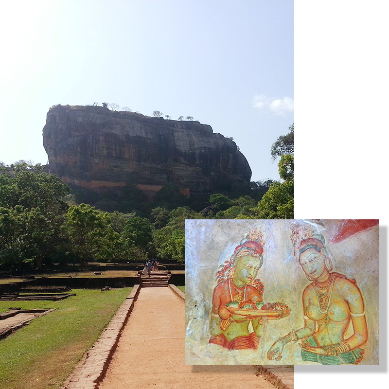 Sigiriya is an ancient rock fortress cum citadel situated in the Matale District close to the town of Dambulla. This magnificent World Heritage Site comprises of a 200m high rock which was transformed into a citadel in the 5th century AD with a palace on the summit and beautiful pleasure gardens and an urban center around the rock surrounded by a rampart and moat. Sigiriya is about 176km from Colombo and can be reached by traveling to Dambulla on the Colombo-Polonnaruwa road and turning right from Inamaluwa junction.
History records that King Kashyapa of the Anuradhapura Kingdom in the 5th century AD after having murdered his father King Dhatusena to claim the throne, shifted his administrative center from Anuradhapura to the more secure Sigiriya in fear of his brother Prince Mugalan who being the rightful heir to the throne had fled to South India. From here Kashyapa ruled for 18 years building a beautiful palace on the summit and a citadel with pleasure gardens around the rock which was protected by a rampart and moat. He was finally defeated in battle by his brother who shifted the Capital back to Anuradhapura and made Sigiriya a monastery. But new archaeological evidence reveals that Sigiriya was occupied from the 2nd century BC as a monastery and that the palace may actually have begun construction during the reign of his father King Dhatusena.
Although Sigiriya appears to have gone out of use from the 7th century AD it remained a tourist attraction from those early times for its wonders such as the Mirror wall, the Paintings gallery, the Lion’s paws and the Palace. These ancient tourists had recorded their experiences in poems on the mirror wall know known as the ‘Sigiri Graffiti’. As described by these poems these are still the main attractions in Sigiriya even today; the Lion’s paws are the remains of the paws of a massive rock cut lion, the entrance to the climb of the rock begins here between its paws and would have once made up of the entire face of the lion with the entrance being through the mouth of the Lion. The other wonder of Sigiriya is its beautiful paintings of maidens found in a gallery on the face of the rock, now although only 22 paintings could be seen, 3 poems records that there were once 500 such paintings. Another stunning feature of Sigiriya is its ingenious hydraulic system where fountains found in the pleasure gardens fed by an underground system still function. Sigirya, fondly called the 8th wonder of the world is considered one of the best examples of urban planning in ancient Sri Lanka and is the prime tourist destination in the country.
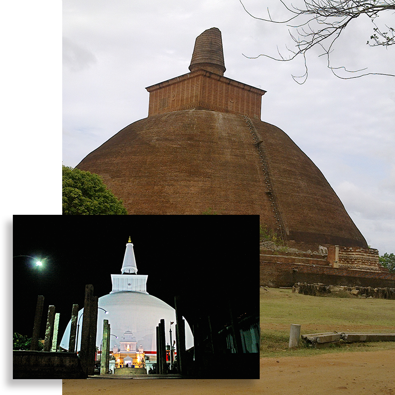 Anuradhapura, located in the North Central Province was the island’s first capital city founded in the 4th century BC by King Pandukabaya and remained the capital till the 11th century AD making it one of the longest reigning capital cities in the world on par with Rome and Constantinople. Written records state that Anuradhapura was founded as a settlement in the 5th century BC by one of the ministers of King Vijaya the first recorded monarch and later expanded into a systematic city by King Pandukabaya in the 4th century BC, but archaeological evidences have shown Anuradhapura to have been a considerable settlement in the 9th century BC and were 75 hectares in extent by the 5th century BC. This ancient metropolis reached its full 100 hectares extent by 250 BC making it the largest city south of the great North Indian cities. With the introduction of Buddhism to the island in the 3rd century BC Anuradhapura became one of the largest Buddhist learning centers in the region. Its fall came during the 1017 AD South Indian Cholar invasions after which the capital was moved to Polonnaruwa.
Anuradhapura’s most important section was the ancient citadel which included the Royal palaces, religious buildings and other important public buildings and was surrounded by a rampart. Surrounding the citadel were the great Viharas or temples. To the was situated the Maha Vihara with the magnificent Ruwanweli Stupa and the Sri Maha Bodhiya- the world’s oldest recorded tree, to the north the Abeyagiriya monastery with the gigantic Abeyagiri Stupa and to the east was the Jethavanaramaya with the world’s largest brick structure the Jethavanarama Stupa. And around these were the giant man-made tanks of the Nuwara wawe, Tissa wawe, and the Abeya wawe. At its zenith Anuradhapura would have represented the peak of Sinhalese, art and architecture having been a capital for over 1000 years and its many sacred sites such as the restored Ruwanweli Seya Stupa and the Sri Maha Bodhiya are still one of the largest pilgrimage sites in the country, this ancient capital was made a World Heritage Site in 1982.
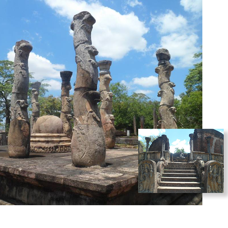 Polonnaruwa was the second Capital of the country in the 11th century after Anuradhapura and represented the zenith of the hydraulic civilization of Sri Lanka. Polonnaruwa was used as a secondary capital city during the latter half of the Anuradhapura period where it also became the royal residence of few Kings in the 7th and 9th centuries. The South Indian Cholar Empire which conquered Anuradhapura in 1017 AD established Polonnaruwa as their center of administration where it was ruled by a Viceroy; the ruined Shiva Devala No. 01 found within the ancient city was built during the Cholar rule. In 1070 the country was liberated by King Vijayabahu I and he chose Polonnaruwa or Pulasthinagara as it was also known, as his Capital city. Polonnaruwa remained the Capital for another 145 years until it fell once again to South Indian invaders in 1215 AD.
The inner city of Polonnaruwa is rectangular in form and is surrounded by a rampart with the Parakramasamudraya or Sea of Parakrama bordering it on the west; within it are found the Palace complex containing the royal Palace of Parakramabahu, the Audience hall and the Kumara Pokuna or Prince Pond and to the west of the Palace complex bordering the Parakramasamudraya tank is the Deepa Uyana with the remains of the Palace and Audience hall of King Nissankamalla. Further within the inner city is found the sacred quadrangle within which are found the ancient Temple of the Tooth relic and other religious monuments such as the Polonnaruwa Watadage, Hatadage, Atadage, Thuparama Image house etc. To the south of the inner city can be found the Pothgul Viharaya and to the north of the city is the massive Alahana Pirivena complex, the Rankoth Vehera, Kiri Vehera, the Lankathilaka Image house, the Gal Viharaya, the Demala Maha Seya and the Thiwanka Image house. Much of these ruins are in a good state of preservation and offer an invaluable insight into the ancient architecture of the period. The ancient city of Polonnaruwa was made a World Heritage Site in 1982.
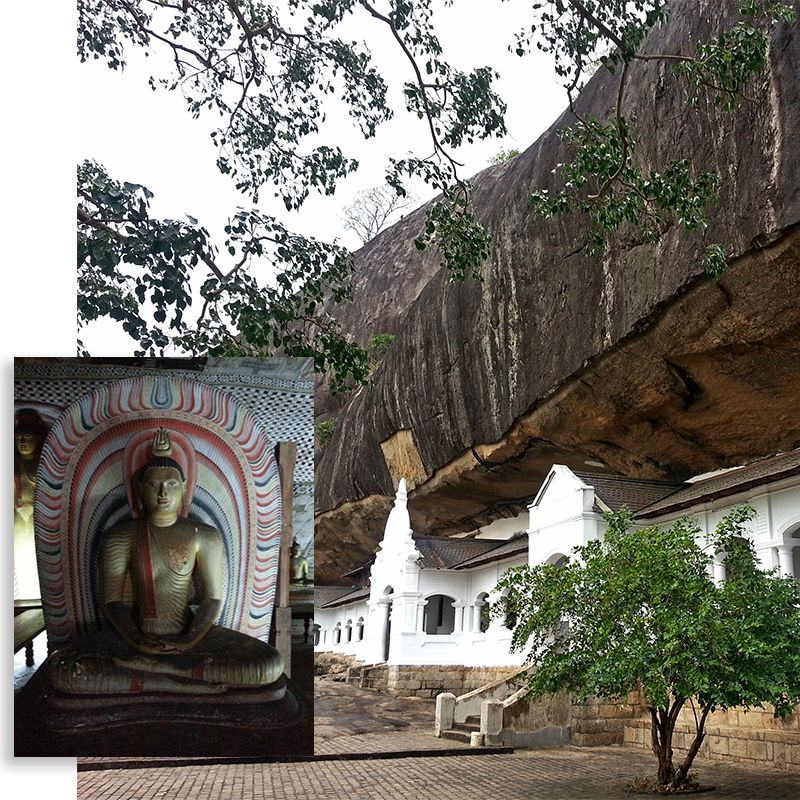 The World Heritage site of the Golden Temple of Dambulla is located in the Matale District of the Central Province and is well known throughout the world for its beautiful cave paintings. This historic cave temple has its origins in the early 3rd – 2nd centuries BC as indicated by the Brahmi inscriptions on the rock but records give its founder as King Valagamba of the 1st century BC. During the Polonnaruwa period this was known as the ‘Swarnagiri Guna’ or Golden Rock Caves and various inscriptions of King Nissankamalla of the Polonnaruwa Kingdom states that he had built 73 golden statues of the Buddha and several stupas. After the fall of the Polonnaruwa Kingdom the temple continued to receive royal patronage from various subsequent rulers and the present condition of its paintings and sculptures are those of the Kandyan Kings of the 17th and 18th centuries.
The main cave of the temple is divided into 5 sub-caves, the Devaraja Lena, Maharaja Lena, Maha Aluthviharaya, Paschima Viharaya and the Devana Aluthviharaya with the latter being as recent as 1915. Cave paintings and statues adorn the ceilings of the caves with the most artistic of all caves being the Maharaja Lena or the Cave of the Great Kings; this cave consists of various standing, seated and reclining images of the Buddha, as well as those of other deities such as Natha, Maithri, Upulwan and Saman amounting to 60. This fascinating temple was made a World Heritage Site in 1991.
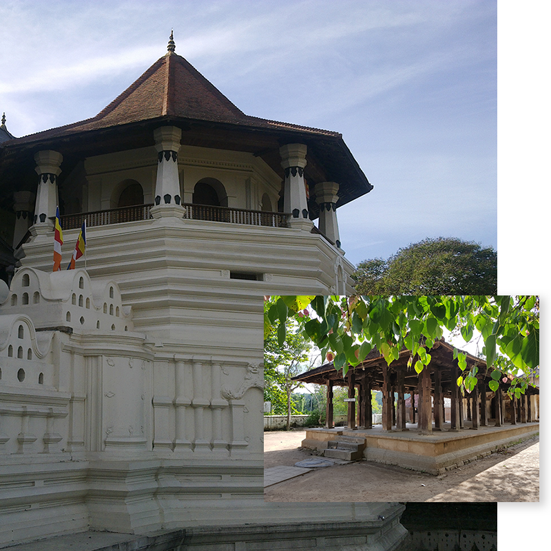 The Sacred city of Kandy, known as Senkadagalapura or Maha Nuwara in Sinhalese was the last Capital city of the Sinhala Kingdom in Sri Lanka which fell to the British in 1815. Kandy, located in the Central Province is surrounded by magnificent hills and is 110km from Colombo. Kandy today is one of the largest cities apart from Colombo and contains a charming mix of old traditional essence with the modern world. This enchanting city is the most sacred place in the country due to the Temple of the Tooth relic or the Dalada Maligawa which houses the tooth relic of the Buddha which had been in possession by the rulers of Sri Lanka since the 3rd century AD.
Kandy was first founded as a city in the 14th century during the Gampola period and became the sole independent capital under King Vimaladharmasuriya I in 1594 and remained so till 1815 where it was betrayed to the British. In Kandy sections of the Royal Palace complex could still be seen such as the Medawahala, the Pallewahala, and the Royal palace entrance building which are used as museums today as well as the Magul Maduwa or Audience Hall. These are situated all within the compound of the Dalada Maligawa and together are separated by a moat and an ornate parapet. The Dalada Maligawa housing the tooth relic was said to have been first built as a two storied palace by King Vimaladharmasuriya I and later modified to three stories. It was burnt down on many occasions by the Portuguese and the present two storied building was constructed by King Sri Veera Parakrama Narendrasinghe in the early 1700s. The iconic Paththiripuwa or the octagon viewing chamber in the front was added last by the last King Sri Wickrama Rajasinghe.
In front of the Temple of the Tooth can be found the historic Natha, Vishnu and Pattini Devalas surrounded by a massive stone wall. To the south of the city is the beautiful Kiri Muhuda or the Lake of Kandy built by the last King. Kandy also had another lake near the present Bogambara Prison which was filled during British times. The general layout of the streets of Kandy is same as it were during the monarchy and some of the Walawas or Mansions of the Nobles which one dotted the city could still be seen. This enchanting sacred capital was made a UNESCO World Heritage Site in 1988.
The only colonial monument to be recognized as a World Heritage Site in Sri Lanka is the impressive 17th century Galle Fort and its old town. Galle, situated in the Southern Province is a prominent tourist destination and home to a fine natural harbour. The Galle harbour is recorded in the 14th century by the famous traveller Ibn Battuta who arrived in the harbour and it was also an important port of the colonial powers of the island, the Portuguese, Dutch and the British. The Portuguese were the first to build a small fortress here in 1588 across the strip of land jutting into the sea covering the harbour from the west. This fortress was attacked and taken by the Dutch and Kandyan armies in 1640 with the Dutch subsequently taking control of the region. Here they built a massive fortress with the ramparts running the entire circumference of the small peninsular amounting to 52 hectares. This fortress is ringed by 14 bastions with the landward side containing the three largest bastions named the Sun, Moon and Star bastions. This fort which was completed by 1729 housed 500 families, the garrison, and numerous administration and commercial buildings as well as a magnificent Dutch Reformed Church. The old town still maintains its colonial legacy with many Dutch and British era buildings and is a unique world of its own; a little 17th century Europe in Sri Lanka. The old entrance to the fort is through the gateway in the center of the large warehouse facing the jetty, this still contains its original doors and the British coat of arms, but the present large entrance near the Moon bastion was built by the British in later times.
Kotte situated in the Western Province in close proximity to Colombo is at present the seat of Parliament and the Official capital of Sri Lanka presently known as Sri Jayawardanapura Kotte. It takes its heritage from the 15th century Capital city of Kotte, the area of which is now a built-up neighbourhood. Before becoming the Capital in the 15th century it was first developed as a fortress in the late 14th century by Nissanka Alakesvara of the Gampola Kingdom to serve as a base for his attacks on the Arya Cakravarti of Jaffna. In 1415 with the ascension of Parakramabahu VI as King, the fortress of Kotte was selected as the Capital due to its superb fortifications and expanded into a beautiful city with further fortifications. Kotte served as the Capital of the kingdom till 1565 when the Portuguese who were defending the Kingdom on behalf of King Dharmapala, decided to relocate the city to Colombo due to the continuous attacks from the Sitavaka Kingdom under Rajasinghe I. It is stated that they demolished all the buildings and used the material to expand Colombo.
Kotte was divided into two sections, as the inner-city and the outer-city, this is still known at present as Ethul Kotte and Pita Kotte; and access to the city was through 7 passes with the only land pass being at Pita Kotte. The inner city was surrounded by a strong rampart built of Kabook or Laterite stones with a deep moat at the south and surrounded by the Diyawanna Lake from the north; while the outer city area was fortified by a moat and rampart from the south which guarded the only land pass to the city. The overall defences were constructed by Nissanka Alakesvara at the inception but the rampart of the inner city area was constructed by King Parakramabahu VI. Several sections of the city could still be found with the most prominent being the ramparts, now reduced to 3-4 feet in height, most of the eastern and southern ramparts are in a relatively good state of preservation while the rest of the ramparts run through private lands. Other ruins include the impressive Veherakanda ruins, Alakesvara’s palace or tomb, some ruins at Parakumba Pirivena, the tunnel entrance at the Kotte Ananda Sastralaya, and even the deep Inner and outer moats of the fortress could still be seen.
A unique feature in Sri Lanka’s tangible colonial heritage is the large number of 17th century Dutch forts that are found throughout the island. The Dutch who replaced the Portuguese as the colonial rulers of the maritime provinces of the island after 1658 built at strategic locations fortresses of various sizes based on the contemporary Bastion fort design. These forts were run as military outposts as well as administrative centers. During the relatively peaceful times of the Dutch the forts saw hardly any action and in 1796 the possessions of the Dutch were handed over to the British without a fight. The British maintained many of the fortresses for their administrative purposes and hence have survived to this day. The three largest forts were the Galle, Jaffna and Colombo fortresses, with the latter being demolished in 1869 with few sections remaining today. The Galle and Jaffna forts remain at present the largest and the best preserved forts in the island, with the latter having sustained severer damage during the country’s civil war and is now being restored. Some of the other prominent forts include the little circular fort of Hammenheil on an island near Jaffna, Negombo, Kalpitiya, Mannar, Trincomalee, Batticaloa forts, the star fort of Matara, and the small two bastioned Katuwana fort. Exploring these forts gives one an inside view to the military aspects of gun powder warfare and a glimpse to a turbulent part in the country’s history.
Out of the western religions in the country Catholicism is the largest having arrived in the island first with the Portuguese in 1505. Although it being the oldest amoung the Christian dominations, the oldest churches in the island goes to the Dutch Reformed Church which dates from the 1700s. This is due to the fact that the Dutch who took over Portuguese possessions in 1658 suppressed Catholicism and destroyed its churches leaving the Dutch Reformed Church the dominant Christianity at the time. Sri Lanka possesses two such magnificent Churches, the Wolvandaal Church in Colombo built in 1749 and the Church of the Galle fort built in 1754. These two monuments serve as a testimony to Dutch architecture and have retained much of its original state including its wooden furniture.
The Wolvandaal Church in Pettah in Colombo built in 1749 served as the primary Church in Colombo for the Dutch Governor. This Church is built in the shape of a Greek cross and constructed in the Doric style. The walls are 1.5 meters thick and are made of Kabook or laterite with the arches built out of bricks. The interior of the Church takes one back in time with its Dutch era furniture as well as the State pew with the beautifully ornate chairs of the Governor and other officers. Within the Church and outside could be found large ornately carved tombstones and plaques dating from the 1700s up to the 1900s. Service is still offered in this Church on Sundays for the small community.
The Galle Dutch Church is situated within the Galle fort and was built between 1752-1754. It is built in the shape of a cross in Dutch architectural style. The windows are of beautiful stain glass and an interesting feature within the Church is the 59 burials and 39 memorial plaques on the walls and with many more in the garden around the church.
A third magnificent Dutch reformed Church stood until recently within the Jaffna fort which was sadly destroyed by artillery fire during the Sri Lankan civil war.
The Balana fort is an impressive little fortress built by the Sinhalese on the Balana pass on the route to Kandy. Balana which means the ‘Look out’ was an important pass through the steep Alagalla mountain range which sheltered the last Sinhalese Capital city of Kandy against the European colonial powers of the Portuguese, Dutch and British. During the Kandyan Portuguese wars of the 16th and 17th centuries the Sinhalese constructed a strong fortress here to halt enemy advances on Kandy. Being situated on a craggy hill many a European writer has written about the toilsome climb up the Balana pass. The fort fell into possession of the Portuguese for a short period in the early 1700s but was regained by the Sinhalese. The fortress was never taken by storm and it was only due to the tactical withdrawal of the Sinhalese forces from the fortress that enabled the Portuguese, Dutch and even the British to march upon Kandy. At present the ruins of the fortress could be still seen and is in a good state of preservation. A unique feature here is of the presence of 3 round bastions against the norm of the angular bastions of the contemporary European fortresses. This is a rare example of Sinhalese fort construction as not many Sinhalese forts have survived apart from the fortified citadels such as Yapahawa and Kotte. The Balana fort could be accessed via the road behind the Kadugannawa railway station.
Dimbulagala is an isolated mountain in the North Central Province, east of Polonnaruwa. Its history dates back to the 4th century BC and was home to a forest Monastery during the Anuradhapura and Polonnaruwa periods. Dimbulagala is presently most famously known for the Dimbulagala Rajamaha Viharaya and its late chief incumbent the Ven. Sri Seelalankara Thero who had served the people of Dimbulagala for decades and was murded in 1995 by the LTTE. Dimbulagala is about 250 km from Colombo and can be reached from Polonnnaruwa by traveling east along the Batticaloa road and turning right from Manampitiya junction to the Manampitiya-Aranaganwila road and from there turning right from Dalukkane junction.
Dimbulagala first associates its self with King Pandukabaya, the first King of Anuradhapura in the 4th century BC when it gave refuge to him during his battles with his uncles. Later during the Anuradhapura period it was converted to a forest monastery and the many caves with drip ledges and Brahmi inscriptions of the 3rd to 2nd centuries BC bears gives evidence to this. It was developed further to a grand monastery during the Polonnaruwa period where inscriptions found here state that Queen Sundera Maha Devi, wife of King Vickramabahu had developed the site. After the fall of the Polonnaruwa Kingdom the monastery had fallen into ruin and was later inhabited by Vedda people who has migrated from Mahiyangana, their descendants are still found in the surrounding villages. It was in the 1930s that the Ven. Sri Seelalankara Thero had first moved here and re-established the present Dimbulagala Rajamaha Vihara.
Its archaeological sites includes the Namal Pokuna archaeological site which is situated on the northern side of the mountain, it includes a monastic complex of an Image House, a Stupa, a Bo tree shrine and another building surrounded by a granite parapet, these ruins dates back to the Anuradhapura period. And further south of these are found several caves scattered about the forest with some containing inscriptions and also a pond. Mara Veediya is the next most important site situated on a high cliff on the southern face of the mountain and containing meditation caves and inscriptions as well as a pond right on the edge of the rock and the climb is only possible by iron rails. The Akasa cheitya is a modern stupa situated on the western edge of the rock just above the present Rajamaha Viharaya which also contains caves with inscriptions. There are another three important archaeological sites around the base of the mountain; the Pulligoda cave paintings are situated on the southern end of the mountain and contain stunning cave paintings of the Anuradhapura period. The site known as Molahetiya Welegala is close by to Pulligoda and contains the remains of an ancient temple and as well as several large rock inscriptions on the surface of the rock. The ruins of the site known as Kosgaha Ulpatha is location a short distance away and contain a large cave with the remains of a Reclining Buddha and as well as a chambered cave situated high above the ground with the only access being from a ladder.
Dimbulagala gives one a thrilling experience of the past along with a stunning experience of the forests of the dry zone.
The Esela Perahera (Pageant) is a celebration of several days in which the people parade through the streets in great glamour accompanying the Sacred Tooth Relic of the Buddha in the city of Kandy, this is also called the ‘Dalada Perahera’ or the Pageant of the Tooth relic. Since the arrival of the Tooth relic in the island in the 3rd century AD, such Peraheras have been held in its honor in all the Capital cities of the island and the tradition of the present Esala Perahera taking place in the month of July and August dates back to the Kandyan Kingdom.
The current Esela Perahera is an amalgamation with the Devale Perahera of the four Devales of the gods Vishnu, Kataragama, Natha and Pattini and has a written history of around three hundred years. During the monarchy, the King himself organized and commenced the Perahera but now this role has been taken over by the Diyawadana Nilame. The Kandy Esela Perahera is the union of history and culture, with the order of the event, the officers, the attire of the participants etc. being same as they were during the days of the Monarchy. It is the only place where one can get a glimpse and experience the traditional Sinhalese culture at its best. Thousands of pilgrims and tourists flock to the city of Kandy to view this magnificent event, the last day of which is the grandest.
The Kandy Esala Perahera begins with the ‘Kap situveema’ which is the dedication of the festival for a successful one. Then the ‘Devale Perahera’ or the Perahera of the four Devales of Vishnu, Kataragama, Natha and Pattini all of which are situated in the city of Kandy takes place. This procession is held for five consecutive nights within the Devale premises around the Ehale gaha (Esala tree) in great celebration with flags, drums etc. From the sixth night commences the ‘Kumbal perahara’; it is called by the name because the Esala Tree is placed in a special structure resembling a Kumbaha or an Ant hill. The Kumbal Perahara goes around the streets of Kandy for five nights taking short routes. Next the ‘Randoli Perahara’ takes place, taking long routes and almost covering entire Kandy City. The Randoli Perahara goes on for another five nights with the last night being the grandest of all for it is on the last night that the Sacred Tooth Relic is taken on procession. Finally the celebrations are concluded with the ‘Diya Kapeeme Mangalya’ or the Water-cutting ceremony. On the last day of the festival after the procession has gone around the streets, it separates into two, with the first part belonging to the sacred Tooth Relic going to the ‘Adhanamaluwa’ and the other which is attached to the four Gods heading towards the place called Gatembe along the Mahaweli River, for the ‘Diya Kapeeme Mangalya. This Perahara is called the ‘Dawal Perehara’ or Daytime Pageant because it takes place during the day. This ceremony is conducted in the Mahavali River where the offices of the respective temples are rowed the middle of the river in a decorated canoes for the ritual.
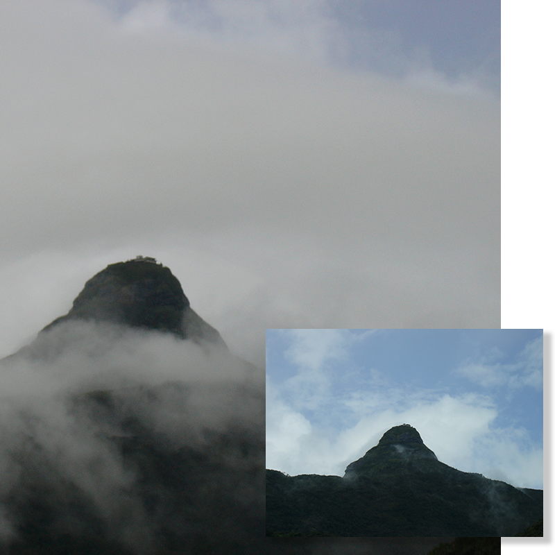 Sri Pada or Adam’s Peak is the fifth tallest mountain in the country at 2,243m on the western edge of the central hills. Sri Pada also known as Samantakuta or the Mountain of God Saman is a Holy Mountain and an important place of pilgrimage in the country for Buddhists as it is believed that the Buddha on his third visit to the island placed his foot print on the summit of the mountain. The mountain itself is unique and is a conical hill rising majestically on the western massif dwarfing the surrounding mountains. It could be seen on clear days from the western coast and was a land mark for ancient navigators. Its pilgrimage tradition falls to the other main religions of Hinduism, Islam and even Christianity. Just as the Buddhist tradition holds it as the site of the Buddha’s foot print, the Hindus believe it to be the footprint of Shiva and the Muslims as that of the first man Adam where he landed when he was thrown out of paradise, and also the 16th century Portuguese claimed it to be that of the Apostle St. Thomas.
For the Muslims, this was considered one of the most sacred sites in the world as way back as the 9th century AD. The Buddhist tradition of the site was held from much earlier times but its pilgrimage tradition begins only in the 12th century during the Polonnaruwa Kingdom under the patronage of King Vijayabahu I. Subsequently many a Sinhalese King had visited and paid homage to the site. The sacred mountain was known throughout the region as is recorded in the annals the famous travellers such as Ibn Bhatuta and Marco Polo.
Today on the summit can be found a Buddhist shrine with a shrine room containing a larger-than-life footprint, where the actual footprint is believed to be buried under. The pilgrimage season starts from the full moon in December till the Wesak full moon in May. There are many rituals on the pilgrimage which is made by two main routes. The two main routes are the Ratnapura-Palabaddala route which is 8.5km to the summit and the other being the Hatton-Nallathanniya route which is 5km to the summit. There are also several jungle trails joining up to the main two trails close to the summit, with the most famous being the Kuruvita-Erathna trail. Both main trails are lit during the season with many facilities along the way for the pilgrims. The climb to the top during the final 800m is the most challenging as it is known as the ‘Mahagiridamba’ or the Great rock climb which is almost a 70 degree climb. This though is made easy with the railings and cement steps, was considered a great danger during ancient times and iron chains were fitted to the rock to aid climbers, remains of which could be seen to this day; this extreme climb has been recorded by many a foreign traveller of old.
The charm of nature and the spirit of the pilgrim is a must be witnessed experience for any traveller; the scenic climb up the holy mountain gives one an enchanting view of Peak Wilderness World Heritage Site with its numerous surroundings and to get a glimpse of the rising sun from the summit is another world altogether. On a clear day with the sunrise, one could get a glimpse of the near perfect triangular shadow of the mountain casting itself on the surrounding. Adams Peak is also a haven for hikers during the off-season.
A center of religious pluralism, Kataragama is an important pilgrimage site for the Hindus and Buddhists of the country. Situated on the banks of the Menik Ganga in the southeast corner of the country in the Uva Province, Katagrama has been a place of worship since ancient times. This Shiva-Buddhist site is known as the adobe of the god Kataragama to the Buddhists and as Lord Murugan to the Hindus. Considered a very powerful deity there are many Hindu and Buddhist shrines within the temple complex and is one of the island’s largest pilgrim sites for both the Sinhalese and the Tamils. Kataragama is also a revered Islamic site with a sacred Mosque in the vicinity and as well as a place of worship for the tribal Vedda people that live in the area, thus adding to the diversity of the site.
The main festival here take place during the months of July and August and enact the episodes of the god’s conquest of the anti-gods and his courtship with Valli, with the festival of the marriage of the god to Valli and the final water cutting ceremony marking the conquest of the anti-gods. Another important Buddhist religious center, the historic Kiri Vehera comprising of a massive 1st century BC stupa too is found near the temple complex.
Dedicated to the Hindu god Murugan also known as Kandaswamy, this is one of the most prominent Hindu temples in the country. Situated in Nallur in the Jaffna town it can be accessed along the Jaffna-Point Pedro road. This is the fourth Kandaswamy temple to be built at the site tracing its history to the 10th century. The original temple was built in 948 AD and was later rebuilt in the 13th century. The third temple’s construction is attributed to Prince Sapumal in the 15th century who was the son of King Parakramabahu VI of Kotte during his occupation of the Jaffna Kingdom. This temple was destroyed by the Portuguese when the Jaffna Kingdom fell to their hands in the early 17th century and a church was built upon its site.
The present temple was built during the Dutch period in 1734 by Ragunathan Maapaana Mudaliya who was an officer in the Dutch Kachchari. His descendants remain the custodians of the temple to this day. The Temple’s golden era was considered during the late 1890s and early 20th century when most of the present features were added beautifying the temple.
The Temple’s main 25 day festival takes place in August annually, its festivals which begins from the Kodietram or the hoisting of the flag are the Manjam, Thirukkarthikai, Kailasavahanam, Velvimanam, Thandayuthepanu, Sapparam, the colourful Chariot festival or the Ther Thiruvila, the water cutting ceremony or the Theertham, and the symbolic wedding ceremony or the Tiru Kalyanam. This 25 day festival attracts thousands of devotees to the Temple and besides this; the Temple conducts various poojas daily.
The Tewatta National Basilica is the only Basilica in the country of the Roman Catholic Church. This huge basilica is set in a splendid 52 acre Rubber estate in the village of Tewatta in Ragama 20km from Colombo. During the Second World War a vow was made 2nd of February 1942 by the Archbishop to the Virgin Mary to build a basilica in her honor if the country would be protected from the war. As Sri Lanka was never invaded by the Japanese, on the 15th February 1947 approval was received from the Vatican for the construction of the basilica and devoted it to Mary under the title ‘Our Lady of Lanka’. On the 4th of February 1951 the foundation stone was laid by the then Archbishop Thomas Cardinal Cooray and was finally completed and blessed on the 6th February 1974.
The Church is made in the shape of a cross and built according to ancient Indian Temple architecture with elements from ancient Sinhalese architecture as well. Built entirely out of granite the church is 310 feet in length. The entrance façade is made up of a portico with six colossal granite pillars with a large white iron crucifix 24 feet in height above it and with two massive towers on either side of the façade. It also has a central dome above the altar with the nave and transepts having a barrel vaulted ceiling. This is a famous pilgrimage site for Catholics especially during its feast of the Sick in August.